
To assist you with your travel arrangement and preparation to attend this learning exchange, please click here or the Travel Information menu above. Kindly read this information carefully and send us your personal information.

Programme
Sunday, 6 May
Proin nec turpis eget dolor dictum lacinia. Nullam nunc magna, tincidunt eu porta in, faucibus sed magna. Suspendisse laoreet ornare ullamcorper. Nulla in tortor nibh. Pellentesque sed est vitae odio vestibulum aliquet in nec leo.
Day 1, 7 May
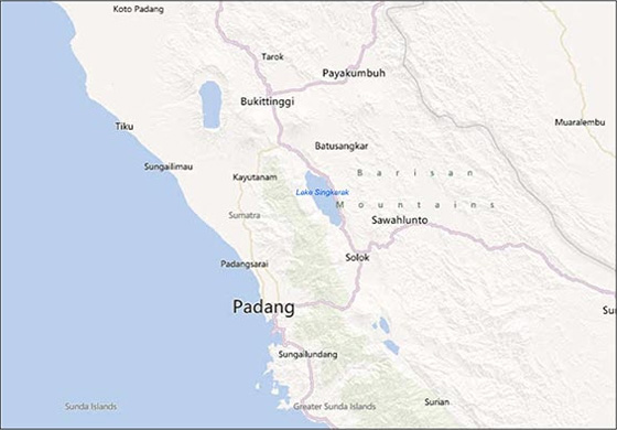
Lake Singkarak: the RUPES project
Back to top »
Background
Singkarak, with its beautiful lake, is a former Minangkabau kingdom. The region is well known for its unique blend of religion and culture. Lake Singkarak is an important source of water for the surrounding agriculture and provides water and electricity for many parts of West Sumatra province. It is also the home of an endemic fish species (Mystacoleucus padangensis or ‘ikan bilih’), a famous delicacy.
The system of governance was changed after the reign of Soeharto from village into ‘nagari’ as part of the decentralization process. The nagari system recognizes the traditional effectiveness of local communities in managing their natural resources. In Singkarak, 13 nagari are located around the lakeshore with the boundaries coinciding with the hydrological sub-catchment. The lake, however, belongs to two different districts: Solok and Tanah Datar. Currently, more than 400,000 people living on Singkarak’s shores and are highly reliant on the lake.
Logging activity in the past time has created thousands of hectare of bare lands, which have not yet recovered. Agricultural activities in the uplands have encouraged infestations of ‘alang-alang’ grass (Imperata cylindrica) in some parts.
Previously, many scientists pointed to erosion in Singkarak as the key problem, with reforestation of the grassland as the main priority for enhancing environmental services, particularly to increase water supply. However, RUPES’ exploration of water-balance models, local ecological knowledge and preferences in the local policy discourse revealed that reforestation might not be the single solution. A survey carried out by RUPES showed that the change of inflow into Lake Singkarak was also caused by the rainfall pattern as well as a hydropower plant.
The development of hydropower in the 1990s brought major changes to the lake's outlets and modified the pattern of rise and fall of the lake. The lakeside communities, for example, have experienced significant decreases in outflow to the Ombilin River during the dry season. The water gate is closed during this time to maintain water levels in the lake. This has disrupted local communities’ livelihoods that depend on the water from the lake.
Indonesian law obliges State-owned companies to distribute royalties to both national and local governments. Thirty-five percent of total royalties, which can also be seen as payments for environmental services, should go to local districts via the provincial government. In the past, the royalties did not reach local people who suffered from the impact of hydroelectricity generation on their livelihoods. As well, the allocations were not designed as incentives to enhance environmental conditions nor were they transparent enough for local communities to be able to improve their livelihoods. At the same time, the communities found that the water quality and inflow of pollution had reduced fish stocks and other direct use values of the lake.
Back to top »
Objectives
RUPES argued that the communities surrounding the lake should receive benefits from the royalties for the environmental service they have provided.
Thus, to present a clear link between land use and environmental services, as well as to facilitate the emergence of appropriate institutional set-ups for managing land use, were two of the objectives in Singkarak.
Back to top »
About RUPES at Lake Singkarak
RUPES tried to ensure that the communities who were willing to participate and took the initiative to protect and improve environmental quality would receive rewards and compensation. It was expected that the local governments and private sector organizations which received benefits from environmental services provided by the communities in Singkarak would follow appropriate principles when distributing their budget to the communities. The system was also expected to increase communities’ participation in protecting and to improving their environment.
During the first phase, RUPES focused on supporting and building the capacity of local communities, institutions and government agencies in Singkarak. We emphasized the implementation of environmental services’ schemes to promote sustainable natural resources management and poverty alleviation among poor upland communities.
In the second phase, which is still continuing, RUPES’ work in Singkarak is focused on the engagement of stakeholders in pro-poor environmental services schemes, including buyers, investors and the intermediary agencies. Innovations in environmental schemes become the major approach of RUPES. We expect to provide some support for developing a national policy framework for voluntary, realistic, conditional and pro-poor rewards for environmental services scheme.
Flowing the money to the communities
Together with the hydropower producer and local communities, RUPES established a scheme to distribute royalties. This not only benefited the communities through the improvement of their economic condition but also provided certain advantages for electricity production. In 2005, Nagari Paninggahan received almost US $40,000 from hydropower royalties, or roughly US $1 per person per year. This system provides a model for application elsewhere since it includes compensation for damage caused to livelihoods to the nagari bordering the lake and also to relatively poor nagari. The funds are intended to provide incentives to maintain environmental conditions. The amount of royalties received depends on the amount of electricity produced thus the stakeholders in return have a strong interest and responsibility to support the better performance of the hydropower company.
Rehabilitation of ‘hulu’ coffee garden
Preliminary analysis by the Indonesian Coffee and Cacao Research Institute showed that the robusta coffee population in the valley is highly variable, as expected from a seed-based coffee establishment, but contains 5–10% of high-yielding trees that can be used for grafting on existing rootstock after pruning.
Nagari Paninggahan is currently revitalizing a 100 hectare, old coffee area, which is a small proportion of the total of over 1000 ha inside their customary forest. They use organic coffee production rules, benefiting from 50 years of no fertilizer input for securing clean water flow into the Lake Singkarak downstream. The revitalization of the coffee plantation is intended to be an alternative livelihood for the communities.
However, some problems need to be solved. One of them is related to land status. The area’s earlier status was as an enclave, which recently was changed by the district government into protection forest. Also, providing comprehensive scientific data on the role of the rehabilitation in relation to biodiversity, water quality and the landscape as a whole is further work that needs to be done in order to gain more acceptance from local government and the communities. To achieve this, RUPES will establish a pilot plot that maintains environmental protection and optimizes communities’ income, based on the premise that better management will also improve the environment.
Clean Lake Singkarak program
Some problems have emerged in the Lake Singkarak area, such as the increasing amount of garbage and other pollution in the lake, decreasing catches of ikan bilih, lake-bank abrasion, sedimentation in the estuary, and a rapid increase of settlements alongside the lake. These problems triggered the idea of creating a cleaner lake for the communities.
The program brought together all stakeholders involved in management of Lake Singkarak to agree on efforts to improve the lake’s condition. Four local governments (Solok district, Solok city, Tanah Datar district and Padang Panjang city) committed to creating programs to clean the lake. This has opened opportunities to expand the program nationally through the Lake Priority Program conducted by the Ministry of Environment. In addition, the communities also established working groups, one of the aims of which is to provide extension programs about the importance of a clean lake for their lives and for those of other communities.
Rehabilitation of grassland into agroforestry through the Voluntary Carbon Market
Marginal land around the lake had the potential to be linked with a carbon sequestration and storage system through reforestation and replanting. One of the systems introduced in Singkarak was the Voluntary Carbon Market (VCM). VCM is expected to provide a flexible and accessible system for developing as well as developed countries. Through this system, reducing emissions of greenhouse gases from the developed world will be easier to achieve and could also improve economic development and environmental conditions in developing countries.
RUPES and CO2OPERATE BV from the Netherlands have initiated a VCM system in Nagari Paninggahan. So far, 50 hectare of land has been registered to the program and planted with various tree species, including fruit, to develop an agroforestry system. The program involves more than 50 households who believe that they will benefit not only with greater incomes but also from their participation to protect the environment, both at the local and global levels.
Replication of the system in other communities around Lake Singkarak, or other places, is possible. However, some points need to be addressed, including clear and transparent mechanisms, full support from all stakeholders involved at local and national levels, and trust among the stakeholders. These will guarantee the success and sustainability of the program in the future.
Environmental Education Centre proposal
In order to integrate RUPES’ projects in Singkarak, as well as to provide a comprehensive and sustainable action to protect the lake, an initiative emerged to establish an Environmental Education Centre (EEC). The EEC is planned to be a centre of knowledge as well as a strategy to assist environmental education becoming closer and integrated with local communities’ daily lives. RUPES argues that environment education is required, particularly for the younger generation because they will be the main actors in the future management of their own natural resources. In addition, the centre will provide information regarding (eco)tourism in Singkarak and the cultures of the Minangkabau people.
In the future, the centre will provide curriculum-based knowledge and skills to students, provide high quality teaching and direct access to RUPES’ programs in the field. An environmentally friendly building is also planned.
Supporting local and national policy frameworks
All RUPES’ projects in Singkarak are aimed at supporting policy at both local and national levels. With the rehabilitation of the hulu coffee garden, the Government is expected to decide on an appropriate policy by considering both the ecological and economic opportunities for the communities. The VCM in Paninggahan is relatively new and unavoidably uses a ‘trial and error’ mechanism.
The lessons learned from this process will contribute to the establishment of relevant policy related to climate change. Later, the clean lake program also require higher level policy development and implementation because the lake is located in two districts with different customary structures and behaviors. Thus, a culture-based policy will also be an important way to achieve the objectives of the program.
Improving the engagement of national and international stakeholders in rewards for environmental services schemes
The VCM in Paninggahan will not be the last scheme implemented in Singkarak. Other areas are waiting to replicate with a similar scheme. Finding potential buyers, both national and international, is another task for RUPES. In addition, Government engagement will be another crucial factor for the success of this scheme. However, participation by other buyers and investors is also required to make the hulu coffee garden and clean lake programs work.
Developing innovation in effective, efficient and pro-poor rewards for environmental services schemes
The program developed by RUPES in Singkarak provides some basic lessons for developing better and innovative rewards for environmental services schemes. The hulu coffee garden provides basic information to develop a mechanism that balances environmental and economic interests. The VCM is the first scheme to establish a contract between the communities as the service providers and the buyers, not only in West Sumatra but also in Indonesia. Finally, the clean lake program could be the initial stage of developing better lake management with integration of social, economic, educational, infrastructure and environmental issues.
Back to top »
Reading materials
- Leimona B, Boer R, Arifin B, Murdiyarso D and van Noordwijk M. 2006. Singkarak: Combining Environmental Service Markets for Carbon and Watershed Functions?. In: Murdiyarso D and Skutsch M,eds. Community Forest Management as a Carbon Mitigation Option: Case studies. Bogor, Indonesia. Center for International Forestry Research (CIFOR). P. 60-73
- van Noordwijk M. 2006. Rapid Hydrological Appraisal (RHA) of potential for environmental service rewards: Procedure and application in Lake Singkarak, West Sumatra, Indonesia. ETFRN News. . (45-46 Winter 2005/06 Forests, water and livelihoods)P. 49-52.
- Lucy Finchett-Maddock. 2010. Observing the impact of RUPES in Lake Singkarak: a legal pluralist perspective on the implementation, integration, and reactions of normative frameworks affected and effected by RUPES’ schemes and an assessment for the future.
- Bontoux N. 2009. Landscape beauty in Minangkabau homeland: study of agro-ecotourism opportunities around Lake Singkarak. Report. Bogor. World Agroforestry Centre.
- Agus F and Farida . 2004. Hydrological impacts of forest, agroforestry and upland cropping as a basis for rewarding environmental service providers in Indonesia Proceedings of a workshop in Padang/Singkarak, West Sumatra, Indonesia, 25-28 February 2004. In: van Noordwijk M,eds. Bogor, Indonesia. World Agroforestry Centre - ICRAF, SEA Regional Office, RUPES, ASB-Indonesia. 143 p.
Back to top »
Map
Day 2, 8 May
Oil Palm in Indonesia linked to trade and investment: Implications for forests
Prepared by Pablo Pacheco
Back to top »
Background
The palm oil industry is anticipating further expansion to fulfill growing demands for food, and to supply palm oil for the biofuels markets. Indonesia is the world’s largest producer of palm oil. Indonesia and Malaysia together supply 85% of the global demand for palm oil. Due to its long history in the development of this commodity, Indonesia offers valuable lessons on the pros and cons of different business models for land use and benefits distribution. The expansion plans for oil palm in Indonesia, however, have also raised concerns about unintended social, economic and environment implications.
Indonesia’s oil palm sector growth was modest until the 1980s and it experienced tremendous growth over the last decade. Between 1990 and 2010, the area of plantations increased 7-fold from 1.1 million ha to 7.8 million ha in 2010 (Direktorat Jenderal Perkebunan, 2011, Sheil et al., 2009). In line with estate expansion, Crude Palm Oil (CPO) production has continued to increase. In 1980, CPO production was 0.72 million tons, this increased to 2.41 million tons in 1990, and rose sharply to 7.0 million tons in 2000. At the end of 2011, Indonesian’s production of CPO reached 23.6 million tons which accounts for approximately 45% of the global output of this commodity (Slette and Wiyono, 2011). Indonesia is striving to maintain its position as the world’s largest palm oil producer, and is planning to expand its production to 40 million tons per year by 2020, twice the volume reached on 2010 (World Bank and IFC, 2011). To achieve this production target, the area of oil palm estates is expected to expand from 7.9 million ha in 2010 to 20 million ha by 2020, likely increasing pressure on forestlands. Annually, the export of CPO and derivatives generates over USD 12 billion in foreign exchange earnings.
The growth of the oil palm sector is largely oriented towards meeting food production needs in major emerging economies such as China and India, as well as Indonesian market. About half of Indonesia CPO production is exported in unprocessed form. Most of the remaining CPO is processed into cooking oil and about half of this is exported as well (Boucher et al., 2011). The rest of CPO is consumed locally.
Furthermore, while the oil palm sector was seen as potentially key to securing Indonesia’s energy needs through CPO biodiesel production, this has not materialized. The biofuels sector has been slow to develop, as indicated by modest growth rates between 2006 and projections through 2011 (Slette and Wiyono, 2011). Recently, the sector has shown signs of growth (Yulisman, 2011). Nonetheless, in aggregate terms still less than 5% of the total CPO production in Indonesia is being used for biodiesel production. The amount of biodiesel produced in Indonesia has increased significantly from a mere 24 million liters in 2006 to approximately 650 million liters in 2011. Some of the biodiesel production is exported, a trend which is increasing. However, these figures do not imply that biofuels are blooming, since capacity utilization remains low. In 2011, it was estimated that capacity utilization was about 17%, leaving most of the biorefineries idle (Slette and Wiyono, 2011). Therefore, biofuel sector expansion is unlikely to pose a threat to food production dependent on CPO in the foreseeable future.
Smallholders’ involvement in oil palm production
The first types of oil palm plantations in Indonesia followed a joint venture scheme between companies and smallholders called a Nucleus Estates and Smallholders (NES) scheme, a system tested in Malaysia in the 1970s and later introduced in Indonesia as Perkebunan Inti Rakyat (PIR) by the transmigration program. The first PIR in the late 1970s were based on rubber plantations, followed by oil palm schemes in the 1980s (Levang, 1997). A more refined version of PIR transmigrasi was ‘Primary Cooperative Credit for Members’ scheme, Koperasi Kredit Primer untuk Anggota (KKPA), under which transmigrants are eligible to obtain subsidized bank loans (Potter and Lee 1998). This scheme emerged at the end of the 1980s. KKPA involves a similar structure to the PIR scheme, including a partnership between a company and smallholders. KKPA could be associated with a transmigration project, with local population joining the KKPA cooperative and transmigrants benefiting from a PIR scheme (McCarthy and Cramb, 2009).
The usual KKPA scheme relies on a contract signed between a company, smallholders grouped in cooperatives, and banks, under the supervision of the government. Farmers entrust their land to the company, which plants, manages and harvests the crops. The landowners are paid a percentage of the harvest revenue after deduction of plantation establishment and management costs. Local governments participate in the process through facilitation of discussions between the partners and land titling. Banks keep land titles as collateral, and the company is responsible for collecting the repayments from the farmers. Charges are made for these services, and they all add to the farmers’ debts. Usually, the deal includes the handing over, from the village to the company, of a percentage of the total land to be developed. This land taken over by the company constitutes the nucleus of the plantation, in opposition to the plasma made up by all the smallholdings participating in the venture (Feintrenie et al., 2010a).
There are three main types of business models for oil palm cultivation in Indonesia: private large-scale plantations (private and stated owned companies) and two types of smallholder models, nucleus estate smallholders and independent smallholders, as mentioned above. According to available data, in 1990, of 1.1 million ha of oil palm plantation, smallholder ownership constituted 25%, state-owned company 33% and private companies 41%. In 2010, around 50% of oil palm plantation was owned by private companies, 42% by smallholders, and only 8% was owned by state-owned companies.
Socio-economic and environmental implications
The promise of biofuels and expansion plans for oil palm plantations has become the subject of a strong political and environmental debate in Indonesia with divided opinions. Some see palm oil as a commodity playing an important role in mitigating climate change, providing alternative sources of energy, and contributing to economic development and rural livelihoods (Basiron, 2007; World Growth, 2009, Basiron, 2010). Others are concerned about potentially serious unintended social, economic and environment impacts (Fitzherbert et al., 2008; ICTSD, 2008; Bringezu et al., 2009, Sheil et al., 2009).
The real picture is much complex. Oil palm development impacts depend largely on the companies’ policy, the local government and the social organization of farmers and communities involved in their production. Most often, local communities are not opposed to oil palm development (Gaiser, 2009;, Orth 2009; Rist et al., 2010; Therville et al., 2011), but are asking for fair share of profits and for keeping the ownership of what they consider as their land (Clerc, 2010; Feintrenie et al., 2010; Feintrenie and Levang, 2011). New investments are expected to underscore partnerships with local communities through outgrower schemes, but questions remain about their effectiveness (McCarthy, 2010).
With regard to oil palm expansion’ environmental negative impacts, it has lead to significant deforestation and carbon emissions, since an important portion of this expansion has taken place in peatlands, thus contributing to carbon emissions (Murdiyarso et al., 2010). Current main concern is that oil palm expected expansion will target secondary forest zone which is exempt from the forest conversion moratorium which Indonesia put into effect in mid-2011 to avoid peatlands conversion, as other land categories will likely become scarce (Boucher et al., 2011; Colchester and Chao, 2011).
Mechanisms supporting more sustainable oil palm production
The Roundtable on Sustainable Palm Oil (RSPO) was established in 2004 and is led by representatives of the palm oil industry. It was funded in answer to the growing concern expressed by NGOs and the global society on the negative impacts of oil palm development on forests and people. The RSPO is a global, multi-stakeholder initiative on sustainable palm oil (RSPO, 2012). Members of RSPO and participants come from many different backgrounds, including plantation companies, manufacturers and retailers of palm oil products, environmental and social NGOs, all originating from countries producing or using palm oil. RSPO has created a certification scheme of sustainable palm oil production. In February 2012, more than 1,336,910 ha of oil palm were certified; 5,704,342 million tons of CPO and 1,324,981 million tons of CSPK were approved for certification (RSPO, 2012). Indonesia, in turn, has put in place its own systems of certification known as Indonesian Sustainable Palm Oil (ISPO). The effectiveness of this system is still under debate, but it is going to be imposed as mandatory to oil palm producers.
Back to top »
Objectives
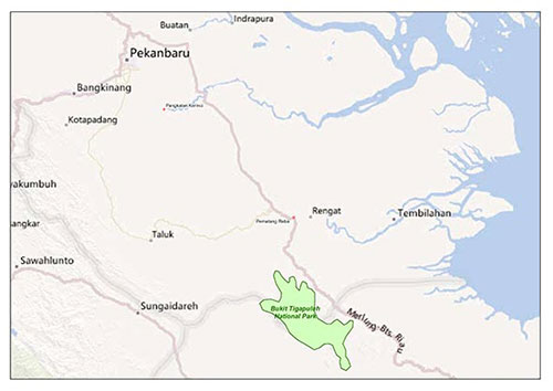
Main drivers affecting future forest conservation are related to increasing investments in oil palm production linked to the expansion of global demand for CPO. Participants will examine the underlying factors explaining oil palm development, and will gain better understanding on their main socio-economic and environmental impacts. There are many trade-offs between economic growth and forest removal linked to oil palm development which depend on different conditions such as land tenure, business models, market access and existing institutions where oil palm takes place. The visit to an oil palm plantation in Riau Province will shed light on the different dimensions of oil palm expansion.
Topics to be covered during this field visit will include:
- Legal and institutions frameworks governing oil palm business and development
- Land acquisition and production partnerships amongst large-scale plantations and smallholders
- Effectiveness of the Roundtable on Sustainable Palm Oil and corporate social responsibility
- On-the-ground realities for oil palm plantations and smallholders involved in oil palm production
The field visit will include the following activities:
- Face-to-face interactions with management team from Musim Mas Group
- Field visit to an oil palm plantation and to an oil palm processing center
Back to top »
About the site
PT Musim Mas Group D
Musim Mas is one of Indonesia's most dynamic groups, with a diversified portfolio of products and assets. Its activities are centred on its core business of palm cultivation and palm oil processing. Musim Mas, which has its business origin in Nam Cheong Soap Factory, was established in 1972. Today, Musim Mas has rapidly expanded into a large fully integrated palm oil corporation, and it currently has a diversified portfolio of products. Musim Mas Group is a market leader in the manufacturing of palm oil, soap and margarine. It owns ships, tankers, a grain terminal and bulk tank terminals. The group ranks among the biggest Indonesian producers in the vegetable oil refining and soap manufacturing industries,
Musim Mas is the first Indonesian member of the Roundtable on Sustainable Palm Oil (RSPO), and has show commitment to supporting and using the RSPO Principles and Criteria for Sustainable Palm Oil Production (RSPO P&C) as the basis of managing the enterprise sustainably. Musim Mas is putting in place practices to advance the adoption of the principles of sustainable agriculture and production. The company launched the Musim Mas initiative on management for sustainability in February, 2007. A phased implementation of sustainability has been rolled out throughout the enterprise. At present two palm oil mills and six estates in the Province of Riau with a total of 23,917 hectares have been certified by RSPO. PT Musim Mas is working towards a full certification of all its business units by 2014.
Riau province
The province economic development benefited first from oil (fossil fuel) production (since 1919), and second from forest and agricultural products. The timber industry, based on natural forest exploitation, became the first economic resource of the province between the 1960s and 1990s. The decline of the resource induced the decline of the industry, conducting it to a conversion to pulp and paper that began in the 1980s (Singer, 2009). Natural rubber was the main cash crop in the beginning of the XXth century. The palm oil industry emerged in 1970s, brought by migrants from North Sumatra province. In the 1980s and 1990s, large companies began planting in Riau, in search either of diversification of revenue from the timber industry, or of new lands to expand their plantations. In 2006, Riau produced 4 million ton of CPO, staggering 25 % of the Indonesian oil palm productive plantations area, and ranking second in the province economic resources, after fossil fuel (Singer, 2009).
Back to top »
Reading materials
- Feintrenie L., S. Schwarze and P. Levang. 2010. Are local people conservationists? Analysis of transition dynamics from agroforests to monoculture plantations in Indonesia. Ecology & Society 15 (4): 37. URL: http://www.ecologyandsociety.org/vol15/iss4/art37/
- McCarthy, J. F., P. Gillespie and Z. Zen. 2012. Swimming upstream: Local Indonesian production networks in “Globalized” palm oil production. World Development 40 (3): 555–569
- Murdiyarso, D., K. Hergoualc’h and L. V. Verchot. 2010. Opportunities for reducing greenhouse gas emissions in tropical peatlands. Proceedings National Academy of Sciences 107(46): 19655–19660
- Obidzinski, K., R. Andriani, H. Komarudin and A. Andrianto. 2012. Environmental and social impacts of oil palm plantations and their implications for biofuel production in Indonesia. Ecology and Society 17(1): 25 http://dx.doi.org/10.5751/ES-04775-170125
References quoted in the text
- Basiron, Y. 2007. Palm Oil Production through Sustainable Plantations. Eur. J. Lipid Sci. Technol. 109: 289-295.
- Basiron, Y. 2010. Environment and Economic Challenges Faced by the Palm Oil Industry – How is MPOC Responding? Makalah disajikan pada Seminar “Reach & Teach Friends of The Industry: Challenges and Opportunities in 2010”, tanggal 2 Februari 2010, Kuala Lumpur.
- Boucher, D., P. Elias, K. Lininger, C. May-Tobin, S. Roquemore and E. Saxon. 2011. The Root of the Problem: What ’s Driving Tropical Deforestation Today? Cambridge, MA, USA.: The Union of Concerned Scientists (UCS).
- Bringezu, S., H. Schutz, M. O´Brien, L. Kauppi, R. W. Howarth and J. McNeely. 2009. Towards sustainable production and use of resources: assessing biofuels. United Nations Environment Programme.
- Clerc, J. 2010. Unpacking tenure security: developments of a conceptual framework and application to the case of oil palm expansion on customary land in Kapuas Hulu regency, West Kalimantan,Indonesia, AgroParisTech-ENGREF, Montpellier, France.
- Colchester, M. and S. Chao. 2011. Oil Palm Expansion in South East Asia: trends and implications for local communities and indigenous peoples. London: Forest Peoples Programme.
- Direktorat Jenderal Perkebunan. 2011. Luas Areal dan Produksi Kelapa Sawit Indonesia 1967-2010.
Feintrenie L, W.K. Chong and P. Levang . 2010a. Why do farmers prefer oil palm? Lessons learnt from Bungo district, Indonesia. Small-Scale Forestry 9 (3): 379-396. - Feintrenie L., S. Schwarze and P. Levang. 2010. Are local people conservationists? Analysis of transition dynamics from agroforests to monoculture plantations in Indonesia. Ecology & Society 15 (4): 37. URL: http://www.ecologyandsociety.org/vol15/iss4/art37/ >
- Feintrenie L. and P. Levang. 2011. Local voices call for economic development over forest conservation: trade-offs and policy in Bungo, Sumatra. Forests, trees and livelihoods 20 (1): 35-49.
- Fitzherbert, E. B., M. J. Struebig, A. Morel, F. Danielsen, C. A. Brühl, P. F. Donald and B. Phalan. 2008. How will oil palm expansion affect biodiversity? Trends in Ecology and Evolution 23(10):538-545.
- Gaiser, N.M. 2009. Perceptions of Oil Palm Cultivation in West Kalimantan – Local Farmers Between Development, Conservation and Indigenous Rights Discourses, Philosophischen und Wirtschaftsund Verhaltenswissenschaftlichen Fakultät der
-
Albert-Ludwigs-Universität Freiburg i. Br. , Freiburg.
ICTSD, 2008. Biofuel Production, Trade and Sustainable Development Policy. International Centre for Trade and Sustainable Development, Geneva. - Levang, P. 1997. La terre d'en face. La transmigration en Indonésie. ORSTOM, Montpellier.
- McCarthy, J. F. and R. A. Cramb. 2009. Policy narratives, landholder engagement, and oil palm expansion on the Malaysian and Indonesian frontiers. The Geographical Journal 175(2):112-113.
- McCarthy, J. F. 2010. Processes of Inclusion and Adverse Incorporation: Oil Palm and Agrarian Change in Sumatra, Indonesia. Journal of Peasant Studies, 37, 821-850.
- Murdiyarso, D., K. Hergoualc’h and L. V. Verchot. 2010. Opportunities for reducing greenhouse gas emissions in tropical peatlands. Proceedings National Academy of Sciences 107(46): 19655–19660.
- Orth, M.G. 2009. The noble savage fancies development - Determinants of community responses to forest conversion plans in Central Kalimantan, Indonesia, Technische universität Dresden, Dresden.
- Potter, L., and J.Lee. 1998. Oil palm in Indonesia: Its role in forest conversion and the fires of 1997/98. report for the WWF - Indonesia Programme.
- Rist, L., L. Feintrenie and P. Levang. 2010. The livelihood impacts of oil palm: smallholders inIndonesia. Biodiversity Conservation 19 (4): 1009-1024.
- RSPO. 2012. Promoting the growth and use of sustainable palm oil. Roundtable on Sustainable Palm Oil. Available from: www.rspo.org (accessed April 2012).
- Singer, B. 2009. Putting the National Back in Forest-Related Policies: The International Forests Regime and the Evolution of Policies in Brazil, Cameroon and Indonesia. PhD thesis at the Institute of Political Studies in Paris (Sciences Po) and CIRAD, 431 pp. Available online from http://www.bsinger.fr/ (accessed Sept. 2011).
- Sheil, D., A. Casson, E. Meijaard, M. v. Nordwijk, J. Gaskell, J. Sunderland-Groves, K. Wertz and M. Kanninen. 2009. The impacts and opportunities of oil palm in Southeast Asia: what do we know and what do we need to know? . Bogor, Indonesia: Center for International Forestry Research.
-
Slette, J. P. and I. E. Wiyono. 2011. Oilseeds and Products Update 2011. Jakarta: USDA Foreign Agriculture Service.
Therville C., L. Feintrenie and P. Levang. 2011. Why should farmers conserve agroforests? Landscape analysis and perception survey in Bungo district (Jambi, Indonesia). Forests, trees and livelihoods 20 (1): 15-33. - World Bank and IFC. 2011. The World Bank Group Framework and IFC Strategy for Engagement in the Palm Oil Sector. Washington, DC.
- World Growth (2009). Palm oil: The sustainable oil. Arlington: World Growth.
- Yulisman, L. (2011) ‘EU may impose higher tariffs on RI biofuel’, Jakarta Post, 6 December.
Back to top »
Map
Day 3, 9 May
REDD+ and Indonesia's forest moratorium
Back to top »
Background
Indonesia's forest moratorium and the development of National REDD+ Strategy are among the deliverables of the partnership on REDD+ between the government of Indonesia and the government of Norway stipulated in the Letter of Intent (LoI) signed on 26 May 2010. To this end both governments have followed the so-called phased-approach that was eventually agreed in Cancun's COP17 in December 2010.
The moratorium is meant to suspend the issuance of new license or permit to convert primary forests and peatlands while forest governance is being improved. It was enacted under the Presidential Instruction, known as Inpres No.10/2011 released on 20 May 2011.
An Inpres is a set of instructions to concerned ministries and other government agencies. Inpres No. 10/2011 issues instructions to three line ministers (Forestry, Home Affairs and Environment) and the heads of five agencies (Presidential Delivery Unit for Development Oversight, National Land Agency, National Coordination Agency for Spatial Planning, National Coordination Agency for Survey and Mapping and the proposed agency to manage REDD+), as well as governors and heads of district governments. The Inpres describes the tasks and the roles of each agency over a 2-year period.
An Indicative Map of Moratorium (IMM) was produced and revised every six months allowing public participations. There are a number of interpretations concerning the extent of area under the moratorium. After the first revision the government figure is 65.5 million hectares (Mha), which consists of 8.4 Mha primary forests and 5.9 Mha peatlands. So the majority are Conservation Forest (21.6 Mha) and Protection Forests (29.6 Mha) which are already protected by Law.
Back to top »
Objectives
Although the moratorium by no means would effectively reduce greenhouse gas (GHG) emissions, it is in line with the President own commitment to reduce GHG emissions as much as 26-41 percent. The Inpres may provide enabling conditions as a stepping stone towards better forest governance. However, the participant may discuss issues such as:
- The fate of the majority of peatlands (around 15 Mha) that are already under concession
- Potential land swapping with degraded forests on mineral soils
- High conservation value of secondary forest excluded from the moratorium
National strategy on REDD+
Indonesia was among the first to engage in REDD mechanism when the extensive stakeholders consultation was facilitated by the World Bank prior to COP13 in Bali, December 2007. Indonesia Forest Carbon Alliance (IFCA) was followed up by the World Bank Forest Carbon Partnership facility (FCPF) when Indonesia was invited to submit the Readiness Plan covering national entity in 2009. At the same time another multilateral initiative under the UN REDD Program was launched to cover sub national activities in Central Sulawesi. Both initiatives are hosted by the Ministry of Forestry.
Bilateral cooperation was also established with the Australian government in 2009 under the Indonesia-Australia Forest Carbon Partnership (IAFCP) that includes REDD as part of post-2012 global climate change regimes. It took the form of a REDD demonstration activities in degraded peatland area in Central Kalimantan. The Kalimantan Forest Climate Partnership (KFCP) project has three components to address:
- Reduction of deforestation and degradation of peat swamp forest by blocking canals to raise the water table, re-establishing tree cover in highly degraded areas, providing livelihood opportunity
- Capture of knowledge from REDD demonstration activities to share within Indonesia and internationally
- Establishment of GHG emissions measurement and monitoring program to link to the National Carbon Accounting System Indonesia (NCASI)
In early 2010 the need of National REDD+ Strategy was accommodated in the LoI to signify the partnership in climate change with a focus on REDD+. There were two versions of strategy document; one was led by the National Development Planning Agency (BAPPENAS) and another one by Ministry of Forestry. When the National REDD Task Force was formed by the President the documents were consolidated and will be launched as a legal document in the near future.
Having had extensive national and sub national consultations the current form of the strategy covers ways and means to:
- establish REDD+ agency, agency to look after the monitoring and reporting of the activities that are ready for verification (MRV), and agency that plays the role as financial instrument to compensate carbon credit generating activities
- develop and implement policies and measures (PAMs) to reduce emissions from deforestation and forest degradation, including alignment of existing laws and regulations associated with spatial planning, forest moratorium and land-use/cover data information
- implement sustainable landscape management with participatory approach that promote environmental and social safeguards, and equitable benefit sharing
Central Kalimantan was selected as REDD province, followed by eight other participating provinces of Aceh, Riau, Jambi, South Sumatra, West Kalimantan, East Kalimantan, West Papua, and Papua.
Back to top »
Reading materials
- Angelsen, A (Ed.).2009. Realising REDD+: National strategy and Policy Options. CIFOR, Bogor. 390p.
- Meridian Institute. 2009. Reducing Emissions from Deforestation and Forest Degradation (REDD): An Options Assessment Report. Washington, DC. http://www.redd-oar.org/links/REDD-OAR_en.pdf
- Ministry of Forestry. 2009. FCPF R-Plan Indonesia. http://www.forestcarbonpartnership.org/fcp/ Node/218
- Murdiyarso, D., K. Hergoualc'h and L. V. Verchot. 2010. Opportunities for reducing greenhouse gas emissions in tropical peatlands. Proceedings National Academy of Sciences 107(46): 19655–19660.
- Murdiyarso D, Dewi S, Lawrence D, and Seymour F. 2011. Indonesia's Forest Moratorium: a stepping stone for a better forest governance. Working Paper No. 76. CIFOR, Bogor, Indonesia.
- Phelps, J., Webb,E.L, Agrawal, A. 2010. Does REDD+ threaten to recentralize forest governance? Science, 328:312-313.
- Ribot, J.C., Agrawal, A., And Larson, A.M. 2006. Recentralizing while decentralizing: How national governments reappropriate forest resources. World Development doi:10.1016/J.Worlddev.2005.11.020.
- Wertz-Kanounnikoff, S and Angelsen, A. 2009. Global and national REDD+ architecture: Linking institutions and actions. In: Angelsen, A (Ed.).Realizing REDD-PLUS: National strategy and Policy Options. CIFOR, Bogor, pp.293-303.
Day 4, 10 May
Protected Areas in Sumatra
Prepared by David Gaveau
Back to top »
Background
Throughout the 1970’s, the Indonesian government generated cash for economic development by logging its vast forest resources in Sumatra, in line with the post-colonial development agenda of industrialized nations (Pretzsch, 2005). A vast network of nature reserves already existed, inherited from the Dutch colonial power, but little was done to prevent logging and forest conversion into these protected areas. During this time, logging concessions were sometimes allowed within reserves. However, three events prompted Indonesia to strengthen its conservation policies in the early 1980’s and to lay the foundation for Indonesia’s current national parks system (Read box 1 to access detailed maps of Sumatran protected areas interactively via Google Earth). These were the UNDP/FAO National Parks Development Project (De Wulf et al., 1981), the promulgation of Indonesia’s first Environmental Management Act (EMA) (Law of 1982, State Gazette 1982, no 3215) and the third World Parks Congress (WPC) held in Bali in 1982 (Sakumoto, 1999). Following this policy change, the Indonesian government strengthened and began expanding the existing network of parks and reserves in Sumatra.
In the early 1980’s, the Indonesian government began to apply a strong law enforcement model within many of Indonesia’s protected areas to safeguard forests (read story in Box 2 on law enforcement in Bukit Barisan Selatan National Park). In the late 1970s, international development agencies such as the World Bank favored law enforcement inside protected areas as a way to reduce deforestation (WorldBank, 1994). Others believed that growing poverty around protected areas placed constraints on the protection of tropical rainforests, and that a key component to conservation success lied in poverty alleviation (Adams et al., 2004). In the mid 1990s, World Bank-funded conservation-with-development projects (ICDPs) became implemented in some of Indonesia’s best known national parks (read story in Box 3 on conservation-with-development in the Kerinci Seblat National Park).
To compensate for the loss of logging revenue following years of over-harvesting that depleted commercial timber stocks by the late 1980s in Sumatra, Indonesia’s Ministry of Forestry began issuing permits in ~1990 to convert some production forests into industrial wood fiber plantations (Kartodiharjo & Supriono, 2000). The Indonesian government bans forest conversion in production forests, where only selective logging is allowed. But, wood fiber plantations had been defined as ‘forest’ by the UN definition (Sasaki & Putz, 2009). Therefore, the conversion of natural forests into wood fiber plantations (e.g., spp. Acacia mangium) has technically not been recognized as ‘deforestation’. The development of industrial oil palm plantations also began by the late 1980s in Sumatra. The Indonesian government had banned forest clearing to oil palm since 2000 (Indonesian Ministry of Forestry, 2000), and oil palm companies asserted that they only established plantations on “degraded lands” (Casson, 1999). Yet this ambiguous term had multiple meanings and often obfuscated the biophysical character of areas classified as degraded, which often included diversity-rich natural forests degraded by logging (Kartodihardjo & Supriono, 2000; Fitzherbert et al., 2008). As a result, the rapid expansion of industrial wood fiber and oil palm plantations lead to massive industry-driven deforestation of natural forests in Sumatra. In 2010, mature oil palm plantations covered >3.9 million hectares (Koh et al., 2011).
Box 1. Maps of Sumatran protected areas available at Sumatranforest.org
Sumatra's network of protected areas spans > 110,000 km2 (58% are watershed protection reserves, 42% are conservation areas). Conservation areas comprise 40 individual reserves established with the aim to conserve biodiversity, including three UNESCO-listed national parks of Gunung Leuser, Kerinci Seblat, and Bukit Barisan Selatan, nature, and wildlife reserves. A Google Earth KML was developed by the author to present precise maps of tropical deforestation in Sumatra's 40 reserves freely at user's fingertips. The maps are available at http://www.sumatranforest.org/sumatranWide.php. They will unfold onto Google's Digital Earth in full resolution by simply activing the relevant links.
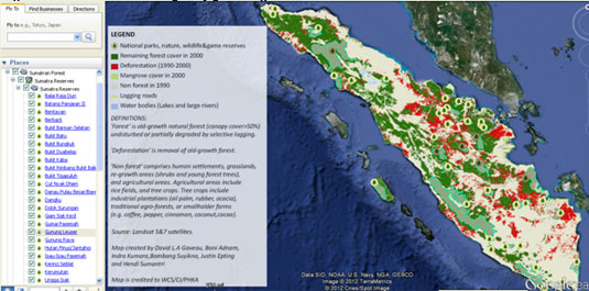
Figure 1. An overview of the protected area network of Sumatra on Google Earth. (snapshot taken from the Google Earth KML available at www.sumatranforest.org)
Island-wide Statistics of deforestation
The combined expansion of: 1) industrial plantations; 2) small-scale forest clearing; 3) roads development in Sumatra (See story in Box 4 on road networks development in Northern Sumatra and in The UNESCO-listed Gunung Leuser), 4) and semi-wildfires lead to one of the World’s highest rates of deforestation in this Indonesian island.
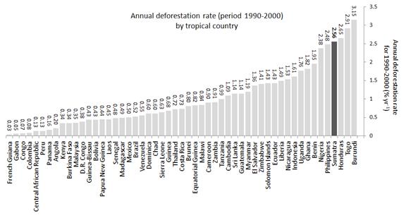
Figure 2. Annual deforestation rate for the period 1990-2000, and per original 1990 forest cover for 52 countries that have some type of wet tropical forests (data from FAO) at. Sumatra is included for comparison.
Sumatra lost 12.5 million ha of natural forest since 1985, i.e. nearly half of its natural 1985 forest cover (Uryu, 2010). The island's forests were cleared and converted at an annual rate of ~500,000 hectares, or 2.56 % yr-1. More than 80 percent of forest loss occurred in the most accessible lowland areas, where the most biodiverse and carbon-dense ecosystems are found. Forest loss was most extensive in the province Riau, which lost 63% or 4.4 million hectares of its 6.9 million hectares of forest cover between 1985 and 2009. Riau accounted for nearly half of Sumatra's total forest loss between 2000 and 2009 (Uryu, 2010). South Sumatra province came second, with 2.4 million hectares lost, or 69% of its 1985 forest cover; followed by Jambi province (1.7 million hectares – 53% of its 1985 forest cover), and North Sumatra province (1.4 million hectares – 43% of its 1985 forest cover).
Box 2. Law enforcement: the case of Bukit Barisan Selatan National Park
The UNESCO-listed 356,000 ha Bukit Barisan Selatan National Park (BBSNP) lies in the provinces of Lampung and Bengkulu in southwestern Sumatra. This park was initially established in 1934 as a nature reserve by the government of the Dutch East-Indies, and later upgraded to the status of national park during WPC Bali in 1982 (De Wulf et al., 1981). Until the 1970s, the area within the now BBSNP was preserved from anthropogenic deforestation by its remoteness, and by the generally low population density across the wider region. But, in 1977 the record high price of robusta coffee triggered unplanned mass migration to the mountainous areas of southwest Sumatra, and initiated a major deforestation front on the eastern fringe of BBSNP, involving an estimated 100,000 immigrants from Java (Scholz, 1983; Benoit et al., 1989). Over the last 34 years agricultural expansion for low-grade robusta coffee production by smallholders has been the dominant driver of deforestation in and around BBSNP (Benoit et al. 1989; De Wulf et al. 1981; Scholz 1983; Suyanto 2007).
Following the creation of BBSNP in 1982, park authorities conducted a several protracted eviction campaigns to remove illegal settlers, who had established coffee plantations inside the park. The illegal settlers had come from poor districts in Central Java to take advantage of high coffee prices. They had settled alongside abandoned logging trails in the Park's southern peninsular. An Indonesian navy-owned logging company had carved a logging road network of >1000 km between 1970 and 1978 in BBSNP before this reserve became upgraded to the status of national park in 1982. The strong emphasis placed on law enforcement in the early 1980s greatly reduced deforestation in the southern peninsular of BBSNP, and subsequently enabled extensive forest re-growth (Gaveau et al., 2009b). However, the effects of law enforcement have waned since the fall of President Suharto in 1998 and with the implementation of regional autonomy in 2000 (Curran et al., 2004). Since 1998, national park budgets have been reduced and patrols declined (ParkOffice, 1982-2004). Equally, the newly democratically elected local and national Indonesian governments have deemed evictions to be morally unjust. Equally, with the implementation of regional autonomy in 2000, local governments have shown little interest in biodiversity conservation because national parks fall under the jurisdiction of the national government and provide few economic returns locally (Levang et al., 2007), which has weakened collaboration between park staff and local authorities. In this context, illegal coffee farmers have become more defiant, and some have taken advantage of recent political changes to return to sites from which they were evicted.
BBSNP reduced had lost 63,700 hectare of natural forest from 1972 until 2006, representing a 21% loss of original 1972 forest cover, at an average rate of 0.62% y-1 An estimated 20,000 metric tons of coffee were produced inside BBSNP in 2006, representing circa 4% of Indonesia's overall annual robusta coffee production (WWF, 2007). Fig. 3 is available interactively on Google's Digital Earth at http://www.sumatranforest.org/southernSumatra.php.
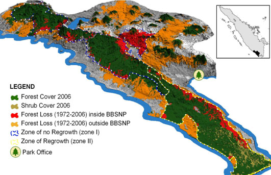
Figure 3. Cumulative forest loss inside BBSNP (red) and in surrounding areas (orange) from 1972 until 2006 within the 11,700 km2 study area. The insert shows the location of the study area (black) in Sumatra. The boundary of BBSNP's zone of no re-growth (Zone I) is in blue. The boundary of BBSNP's zone of re-growth (Zone II) is in yellow. The data are overlaid on a Digital Elevation Model (DEM) and LANDSAT satellite imagery to generate a three-dimensional grey color composite background. Taken from (Gaveau et al., 2009b)
Box 3. Conservation-with-development: The case of Kerinci Seblat National Park
The UNESCO-listed Kerinci Seblat National Park (KSNP) was initially established as a nature reserve by the government of the Dutch East-Indies, and later upgraded to the status of national park in 1986. KSNP is the second largest national park in Indonesia, covering >1 million hectares. It became formally gazetted in 1999. The importance of KSNP's biodiversity has lead to its inclusion in a UNESCO Tropical Cluster World Heritage Site along with Bukit Barisan Selatan and Gunung Leuser National Parks. Much of the park lies in remote mountainous areas, and is de facto protected by inaccessibility. The park's more accessible foothills are threatened by illegal logging and illegal forest conversion to small-scale farmland (Linkie et al. 2004).
Following a shift from law enforcement to Conservation-with-development projects in the late 1980s, a US$19 million Integrated Conservation and Development Project (ICDP) was implemented in KSNP in the 1990s to reduce these threats by help the economic development of villages bordering the park. This project had a community-based conservation focus and aimed to involve local people through joint decision-making and benefit sharing.
The KSNP ICDP failed in its aim of preventing forest loss (Linkie et al., 2008). This failure may have been partly due to factors such as the size and complexity of the project, the nature of the funding, and bureaucratic constraints (Smith et al. 2003a; World Bank 2003; Sodhi et al. 2006). In addition, the ICDP took place during a period of decentralisation for the natural-resource-use sector, which led to a breakdown in law and order and increased illegal logging (Smith et al. 2003b; World Bank 2003). However, ICDPs have been criticized for having indirect and ambiguous conservation incentives (Barrett & Arcese 1995; Sayer et al. 2000; du Toit et al. 2004), and this may have also played a role in the Kerinci Seblat ICDP.
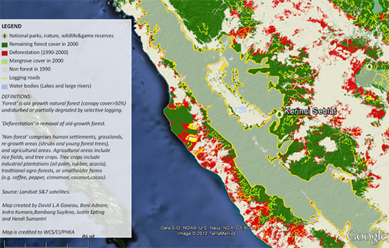
Figure 4. Kerinci Seblat National Park (snapshot taken from the Google Earth KML available at www.sumatranforest.org)
Box 4. Road development: the case of Gunung Leuser National Park.
Northern Sumatra (65,000 km2) includes the Leuser ecosystem and the Gunung Leuser National Park, straddling Aceh and Sumatra Utara provinces. It holds around 6,100 or 92% of the remaining 6,600 Sumatran orangutans (Meijaard & Wich, 2007; Wich et al., 2008). Northern Sumatra's forests are threatened by oil palm expansion, and particularly so the lowland peat swamp areas (Marks, 2009) estimated still to be home to >2,250 or 37% of northern Sumatra's orangutans (Wich et al., 2008) and by extensive road developments, dubbed the "Ladia Galaska". Aceh province has been devastated both by the tsunami of 26 December 2004, and by 30 years of armed conflict between an independence movement and Indonesia's national government (Reid, 2006). Since the tsunami, the international community has helped rebuild infrastructure and peace in Aceh by providing over US$ 4 billion in humanitarian and reconstruction aid (Benthall, 2008). The Indonesian government has earmarked some of the funds to planned extensions of northern Sumatra's road network, both to rebuild Aceh and to attract investments in oil palm plantations. An estimated >500 km of this new road network is extending through the interior of northern Sumatra at fourteen different locations, including inside the Gunung Leuser National Park. Fig. 5. Northern Sumatra, showing Gunung Leuser national park. Available interactively at http://www.sumatranforest.org/northernSumatra.php
Over 39,447 km2 (61%) of northern Sumatra that has been monitored by satellite since 1990 (65,000 km2) was covered by natural forest in 1990, but 3,295 km2 of this original forest cover had been lost by 2006 (Fig. 5), at the same proportional rate of 0.52% yr-1 as the rest of the Earth's humid tropical forests (Achard et al., 2002). Throughout the 1990s, large-scale investments in extractive industries were high. Conservatively, an estimated >40% of the deforested area was directly converted to industrial plantations mainly of oil palm and rubber, while mechanized logging had expanded into standing forest by carving a 5,400 km logging trail network, indicating extensive forest degradation. Over two-thirds (71%) of the lowland forest area (<500m a.s.l), including peat swamps had been lost to industrial plantations. If currently planned roads were built and paved, and extractive industries continued to expand at the highest recorded rate of deforestation calculated for the period 1990-2000, it is estimated that deforestation rates could accelerate, and reach 385 km2 yr-1 (Gaveau et al., 2009c). Conservatively, an estimated >1,384 orangutans, >25% of the current population would disappear, while those remaining would face increased threats from encroachment, conflicts with humans and extensive habitat fragmentation (Fig. 2). These predicted losses of orang-utans would largely arise from steep (56%) losses of forest cover in carbon-rich lowland forests (<500m a.s.l), which is the preferred habitat for dense populations of orang-utans (van Schaik et al., 1995; Wich et al., 2004a) a region also targeted by extractive industries">
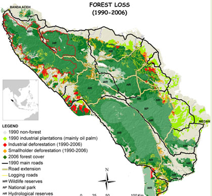
Figure 5. Northern Sumatra, showing Gunung Leuser national park. Available interactively at http://www.sumatranforest.org/northernSumatra.php
The role of protected areas in reducing industry-driven deforestation
Despite massive industry-driven deforestation in Sumatra, protected areas effectively prevented government-sanctioned industry-driven deforestation (Gaveau et al., 2009a). Apart from two nature reserves that have suffered massive industry-driven deforestation within their boundaries (read story in Box 5 on industry driven deforestation in the Bentayan and Dangku Nature Reserves); forest conversion to industrial plantations (i.e. oil palm, rubber or wood fiber) has been minimal within protected area boundaries. The Indonesian government generally did not issue plantation concessions within the boundaries of protected areas. Companies might have played with definitions of what constitutes ‘forest’ to be granted leases in production forests, or they might have converted forests a little bit beyond their allocated concessions boundary, on the grounds that boundaries are sometimes a bit fuzzy given all the lack of unified and coherent landuse maps, but companies generally did not receive concessions rights within protected areas. It has been far more common for logging companies to operate outside of their concessions, and into protected forests, as logging is less easily detected than conversion to agriculture.
This positive assessment comes with some caveats, however. The growth of the Sumatran protected area network since 1982 has not slowed the overall development of industrial plantation around then because protected areas have been placed where we least needed them (leader-williams 1990, Pressey 1993). Lowland forests in Sumatra are priority areas for biodiversity conservation. But, in Sumatra, the protected area network has generally been established in remote highland areas, and other agriculturally unsuitable areas (Gaveau et al., 2009a), where biological diversity is generally the lowest. For example, Sumatra’s two largest national parks Kerinci Seblat and Gunung Leuser protect large tracts of inaccessible forests in the mountains. Additionally, the government has, simultaneously disproportionately sanctioned the conversion of lowland forests to industrial plantation (Gaveau 2009, curran 2004). All oil palm and timber concessions are granted in lowland forests. This double ‘location bias’ severely hampered the ability of Sumatran protected areas to slow the overall island-wide sanctioned progression of industrial plantations into unprotected natural forests.
Do Sumatran protected areas succeed in protecting forests?
The largest share of illegal deforestation in Sumatran protected areas can be attributed to small-scale farmers (whether migrant farmers or local populations). Small farmers are often encouraged to grab protected by local governments, and local speculators who have little interest in biodiversity conservation because national parks provide few economic returns locally (Levang et al., 2007). Industry-driven deforestation in protected forests has been minimal. However, land grabbing by agro-businesses around protected areas is increasing their isolation by destroying important forest corridors surrounding protected areas (read story in Box 6 on industry-driven deforestation around Bukit Tiga Puluh national park). Furthermore might pushed small farmers towards the forest edge and into protected areas. The indirect role of agribusiness in promoting deforestation in protected areas must be accounted for. ENSO_related wildfires have also been a major cause of unsanctioned deforestation in protected forests lying on peat lands in the more arid south-eastern part of Sumatra (Jambi and south Sumatra provinces) (see story in Box 7 on wildfires in the Berback national park). Over 35% of Sumatra’s 40 PAs set aside to conserve biodiversity (national parks, nature, wildlife and game reserves, and recreational parks) have experienced severe rates of forest loss (>1% year-1) during 1990-2000, while 60% have been encroached upon by logging trails indicating extensive forest degradation (Table 1).
Box 5. Boundary conflicts and industry-driven deforestation in protected areas: the case of Bentayan and Dangku nature reserves
The 31,732 ha and 19,300 ha Dangku and Bentayan Nature Reserves in South Sumatra province were established during the 1980s. Local communities and local authorities have always contested the exact boundary of these two reserves. Transmigrants and indigenous farmers are all encroaching on the reserves. Oil Palm companies have been granted oil palm leases into the reserves by local authorities, so that much of the reserves have been converted into industrial oil palm plantations.
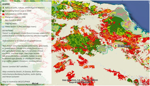
Fig. 6. Dangku and Bentayan reserves (snapshot taken from the Google Earth KML available interactively at www.sumatranforest.org)
Box 6. Boundary conflicts and industry-driven deforestation in protected areas: the case of Bentayan and Dangku nature reserves
The Bukit Tiga puluh landscape (320,000 ha) includes the 140,000 ha Tiga Puluh National Park, established in 1995 by Ministerial decree. This Park protects the steepest slopes, while the flatter surrounding lowland areas are designated as ‘production forests’. The ‘production forests’ around the park have been logged during the 1990s, causing some degradation, but no deforestation, in accord with Indonesia’s land-use plans that ban forest conversion in ‘production forests’. To compensate for the loss of logging revenue following years of over-harvesting that depleted commercial timber stocks in the Bukit Tiga Puluh landscape, Indonesia’s Ministry of Forestry issued permits to three companies to convert >100,000 ha of ‘production forests’ into industrial wood fiber plantations. These three companies are: 1) Sinar Mas Group/Asia Pulp&Paper, 2) Royal Golden Eagle Group/Asia Paper Resources International Limited, and 3) PT Lestari Asri Jaya/Barito Pacific Group (WWF 2011 http://news.mongabay.com/2011/0514-google_earth_sumatra.html). The Indonesian government bans forest conversion in production forests, where only selective logging is allowed. But, the conversion of natural forests into timber plantations (e.g., spp. Acacia mangium) is not regarded as deforestation according to the United Nations definitions of what constitutes ‘forest’ (Sasaki & Putz, 2009). As a result, the forests surrounding the park are under immediate threat of being converted to industrial timber plantations (Hutan Tanaman Industri) to supply wood to local paper mills. The paper made from these plantations will be sold around the World.
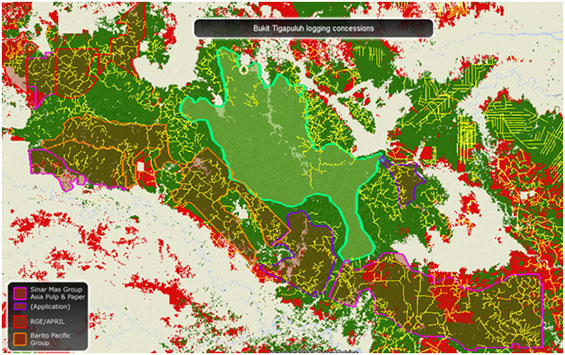
Figure 6. Bukit Tga Puluh national park logging roads ative during 1990s are the yellow lines (snapshot taken from the Google Earth KML available at www.sumatranforest.org). Also check out the tour created for the WWF to help save the Bukit Tiga Puluh landscape at: http://earth.tryse.net/
Box 7. Boundary conflicts and industry-driven deforestation in protected areas: the case of Bentayan and Dangku nature reserves
Berback National Park lies on peat swamps on the eastern flat coastline of Jambi province in Southeastern Sumatra. It was initially established as a nature reserve by the government of the Dutch East Indies in 1935, and later became upgraded to the status of a wetland of international importance under the Ramsar convention, and a national park in 1992. Major wildfires occurred in Berback during two El Ninio years in 1994, and in 1997, destroying about 16,000 ha in the central area of the park. It is estimated that at least 25% of the Park has been affected by illegal logging and fires.
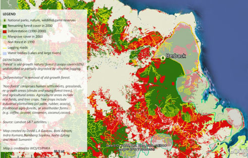
Figure 7. Berback national park (snapshot taken from the Google Earth KML available at www.sumatranforest.org)
Table 1. Statistics for losses in forest cover and logging from 1990 to 2000, shown for each conservation protected area in Sumatra (n = 40).
Name |
Status |
Area |
1990 Forest cover |
Forest loss (km2) |
Rate of loss |
Logging trails |
Balai Raja Duri |
WR |
167 |
113.5 |
102.6 |
9.04 |
789 |
Batang Pangean II |
NR |
504 |
471.7 |
11.8 |
0.25 |
51 |
Bentayan |
WR |
356 |
213.6 |
121.8 |
5.70 |
452 |
Berback |
NP |
1,687 |
1,578.7 |
386.3 |
2.45 |
882 |
Bukit Barisan Selatan |
NP |
3,276 |
2,668.6 |
152.7 |
0.57 |
60 |
Bukit Batu |
WR |
234 |
226.7 |
1.4 |
0.06 |
92 |
Bukit Bungkuk |
GR |
128 |
115.8 |
2.0 |
0.17 |
57 |
Bukit Duabelas |
NP |
610 |
563.0 |
20.5 |
0.36 |
1,370 |
Bukit Kaba |
RP |
145 |
82.2 |
23.7 |
2.88 |
0 |
Bukit Rimbang Bukit Baling |
WR |
1,362 |
1,239.3 |
2.1 |
0.02 |
236 |
Bukit Tigapuluh |
NP |
1,394 |
1,332.4 |
1.6 |
0.01 |
1,134 |
Cut Nyak Dhien |
NR |
57 |
33.7 |
0.2 |
0.07 |
0 |
Danau Pulau Besar/Bawah |
WR |
259 |
232.3 |
0.6 |
0.03 |
276 |
Dangku |
WR |
492 |
322.4 |
44.0 |
1.37 |
629 |
Dolok Surungan |
WR |
269 |
241.7 |
9.6 |
0.40 |
0 |
Giam Siak Kecil |
WR |
850 |
635.6 |
14.7 |
0.23 |
452 |
Gumai Pasemah |
WR |
461 |
335.9 |
4.6 |
0.14 |
0 |
Gunung Leuser |
NP |
8,858 |
8,693.2 |
98.2 |
0.11 |
647 |
Gunung Raya |
WR |
482 |
103.0 |
16.3 |
1.58 |
0 |
Hutan Pinus/Jantahoi |
NR |
166 |
133.1 |
0.1 |
0.00 |
0 |
Isau-Isau Pasemah |
NR |
157 |
73.2 |
1.4 |
0.19 |
0 |
Kerinci Seblat |
NP |
13,562 |
12,733.2 |
135.3 |
0.11 |
386 |
Kerumutan |
WR |
963 |
952.1 |
3.3 |
0.03 |
177 |
Lingga Isak |
GR |
862 |
819.1 |
11.4 |
0.14 |
0 |
Padang Sugihan |
WR |
879 |
516.1 |
507.9 |
9.84 |
1,390 |
Rawa Singkil |
WR |
911 |
859.1 |
43.9 |
0.51 |
387 |
Sebanga |
EC |
58 |
46.1 |
37.1 |
8.05 |
212 |
Semidang Bukit Kabu |
GR |
105 |
29.4 |
24.0 |
8.16 |
0 |
Siberut |
NP |
1,770 |
1,586.9 |
9.9 |
0.06 |
0 |
Siranggas |
WR |
70 |
54.4 |
0.1 |
0.02 |
0 |
Sultan Syarif Kasyim Minas |
GPF |
61 |
54.8 |
27.6 |
5.03 |
466 |
Sungai Dumai |
RP |
25 |
19.9 |
4.1 |
2.03 |
0 |
Sungai Sembilang |
NP |
2,007 |
751.1 |
396.5 |
5.28 |
0 |
Tasik Belat |
WR |
22 |
20.4 |
0.0 |
0.00 |
8 |
Tasik Besar/Tasik Metas |
WR |
26 |
20.7 |
0.1 |
0.03 |
0 |
Tasik Serkap |
WR |
61 |
59.7 |
0.2 |
0.03 |
32 |
Tasik Tanjung Pulau Padang |
WR |
52 |
49.0 |
0.2 |
0.03 |
49 |
Tesso nilo* |
NP |
382 |
355.4 |
80.0 |
2.25 |
1,835 |
Wan Abdul Rachman |
WR |
218 |
32.0 |
0.0 |
0.00 |
0 |
Way Kambas |
NP |
1,293 |
617.2 |
62.3 |
1.01 |
234 |
(*PAs created after 2000. WR: wildlife reserve; NR: nature reserve; NP: national park; GR: game reserve; RP: recreational park; EC:elephant centre)
Previous studies estimated the performance of Sumatran protected areas by comparing deforestation rates inside and outside protected area boundaries. These studies had concluded that protected areas succeed in protecting tropical forests, while logging concessions promote their destruction. As a result there has been reticence from the international community to include protected areas within global REDD+ climate agreements.
A new scientific study re-assessed the effectiveness of parks and reserves in Sumatra for protecting forests, finding that parks and reserves suffer similar rates of unsanctioned deforestation as that found in production forests (Gaveau et al., 2012).
The new study warns that previous studies on protected area effectiveness over-estimated the performance of protected areas because they did not control for government-mediated access in the form of sanctioned forest conversion to industrial plantations in unprotected areas. Just as deforestation rates within remote protected areas should not be compared with rates from less remote unprotected areas, deforestation in protected areas should not be compared with industry-driven rates of loss in unprotected areas.
The Indonesian government has pledged to reduce deforestation and maintain areas of land where the forest remains intact. Protected areas and production forests fulfil this role because they guard forests against conversion. The new study supports the opinion that Sumatran protected areas should receive REDD+ investment because they suffer the same rate of deforestation as production forests eligible for such funds. REDD+ funding for protected areas will provide much needed long-term support, and help improve protection levels in key biodiversity areas across Sumatra.
Back to top »
Objectives
Main drivers affecting future forest conservation in the protected areas are: 1) agricultural encroachments by land-seeking smallholder farmers, 2) increasing investments in industrial plantations in surrounding unprotected areas, linked to the expansion of global demand for palm oil, rubber, pulp and paper; 3) national and provincial land-use plans that promote forest conversion in lowland forests, and forest protection on steep slopes; 4) El-Ninio-related wildfires, 5) boundary conflicts and lack of proper definitions of what constitutes ‘forest’, 6) little interest in protected areas because they provide few economic returns.
In the Bukit Tiga Puluh landscape, forests are threatened by the expansion of timber plantations (HTI) for pulp&paper.
Participants will examine the underlying factors explaining the development of industrial timber plantations (HTI), and will gain better understanding on their main socio-economic and environmental impacts. The visit to a timber plantation in Bukit Tiga Puluh landscape will shed light on the different dimensions of pulp&paper expansion.
Topics to be covered during this field visit will include:
- Legal and institutions frameworks governing pulp&paper business and development;
- Land acquisition and production partnerships amongst large-scale plantations and smallholders ;
- Assessing the feasibility of including existing protected areas into REDD;
- On-the-ground realities for timber plantations, highlighting the constraints they might be facing.
- On-the-ground realities for the management of Bukit Tiga Puluh national Park
The field visit will include the following activities:
- Face-to-face interactions with management team from 1) Sinar Mas Group/Asia Pulp&Paper, 2) Royal Golden Eagle Group/APRIL, and 3) Barito Pacific Group
- Field visit to a timber plantations, and to a local mill.
- Visit to WWF local headquarters, and to the national park office.
Back to top »
Reading materials
References
- Achard, F., Eva, H. D., Stibig, H. J., Mayaux, P., Gallego, J., Richards, T. & Malingreau, J. P. (2002) Determination of deforestation rates of the world's humid tropical forests. Science, 297, 999-1002.
- Adams, W. M., Aveling, R., Brockington, D., Dickson, B., Elliott, J., Hutton, J., Roe, D., Vira, B. & Wolmer, W. (2004) Biodiversity conservation and the eradication of poverty. Science, 306, 1146-1149.
- Benoit, D., Levang, P., Pain, M. & Sevin, O. (1989) Transmigration et migrations spontaneés en Indonésie. Transmigration and spontaneous migrations in Indonesia : Propinsi Lampung, ORSTOM, Paris.
- Benthall, J. (2008) Have islamic aid agencies a privileged relationship in majority muslim areas? The case of post-tsunami reconstruction in Aceh. The Journal of Humanitarian Assistance.
- Casson, A. (1999) In Program on the Underlying Causes of Deforestation Center for International Forestry Research, Bogor Indonesia.
- Curran, L. M., Trigg, S. N., McDonald, A. K., Astiani, D., Hardiono, Y. M., Siregar, P., Caniago, I. & Kasischke, E. (2004) Lowland forest loss in protected areas of Indonesian Borneo. Science, 303, 1000-1003.
- De Wulf, R., Supomo, D. & Rauf, K. (1981) Food and Agriculture Organisation, Bogor.
- Fitzherbert, E. B., Struebig, M. J., Morel, A., Danielsen, F., Bruhl, C. A., Donald, P. F. & Phalan, B. (2008) How will oil palm expansion affect biodiversity? Trends in Ecology and Evolution, 23, 538-545.
- Gaveau, D. L. A., Curran, L. M., Paoli, G. D., Carlson, K. M., Wells, P. L., Besse-Rimba, A., Ratnasari, D. & Leader-Williams, N. (2012) Examining protected area effectiveness in Sumatra: importance of regulations governing unprotected lands. Conservation Letters, 0, 1-7.
- Gaveau, D. L. A., Epting, J., Lyne, O., Linkie, M., Kumara, I., Kanninen, M. & Leader-Williams, N. (2009a) Evaluating whether protected areas reduce tropical deforestation in Sumatra. Journal of Biogeography, 36, 2165-2175.
- Gaveau, D. L. A., Linkie, M., Suyadi, S., Levang, P. & Leader-Williams, N. (2009b) Three decades of deforestation in southwest Sumatra: effects of coffee prices, law enforcement and rural poverty. Biological Conservation, 142, 597-605.
- Gaveau, D. L. A., Wich, S., Epting, J., Juhn, D., Kanninen, M. & Leader-Williams, N. (2009c) The future of forests and orangutans (Pongo abelii) in Sumatra: predicting impacts of oil palm plantations, road construction, and mechanisms for reducing carbon emissions from deforestation. Environmental Research Letters, 4, 11pp.
- Indonesian Ministry of Forestry (2000) MoF Decree No. 603/2000.
- Kartodihardjo, H. & Supriono, A. (2000) CIFOR, Bogor, Indonesia.
- Kartodiharjo, H. & Supriono, A. (2000) (ed C. O. P. N. (E)).
- Koh, L. P., Miettinen, J., Liew, S. C. & Ghazoul, J. (2011) Remotely sensed evidence of tropical peatland conversion to oil palm. PNAS.
- Levang, P., Sitorus, S., Gaveau, D. L. A. & Abidin, Z. (2007) Centre for International Forestry Research, Bogor.
- Linkie, M., Smith, R. J., Zhu, Y., Martyr, D. J., Suedmeyer, E., Pramono, J. & Leader-Williams, N. (2008) Evaluating biodiversity conservation around a large Sumatran protected area. Conservation Biology, 22, 683-690.
- Marks, K. (2009) The Independent.
- Meijaard, E. & Wich, S. A. (2007) Putting orang-utan population trends into perspective. Current Biology, 17, R540.
- ParkOffice (1982-2004) Bukit Barisan Selatan National Park Office, Kota Agung.
- Pretzsch, J. (2005) Forest related rural livelihood strategies in national and global development. Forests, Trees and livelihoods, 15, 115-127.
- Reid, A. (2006) Verandah of violence, the background to the Aceh problem, National University of Singapore Press.
- Sakumoto, N. (1999) In Reforming laws and institutions in Indonesia:an assessment (eds Hardjsoemantri & N. Sakumoto), ASEDP nº51, IDE/JETRO.
- Sasaki, N. & Putz, F. E. (2009) Critical need for new definitions of "forest" and "forest degradation" in global climate change agreements. Conservation Letters, 2, 226-232.
- Scholz, U. (1983) The natural regions of Sumatra and their agricultural production pattern : a regional analysis, Central Research Institute for Food Crops ; Padang : Sukarami Research Institute for Food Crops, Bogor.
- Uryu, Y. (2010) (ed WWF-Indonesia), Jakarta.
van Schaik, C. P., Priatna, A. & Priatna, D. (1995) In The neglected ape (eds R. D. Nadler, B. M. F. Galdikas, L. K. Sheeran & N. Rosen), Plenum Press, New York. - Wich, S. A., Buij, R. & van Schaik, C. P. (2004a) Determinants of orang-utan density in the dryland forests of the Leuser ecosystem. Primates, 45, 177-182.
- Wich, S. A., Meijaard, E., Marshall, A. J., Husson, S., Ancrenaz, M., Lacy, R. C., van Schaik, C. P., Sugardjito, J., Simorangkir, T., Traylor-Holzer, K., Doughty, M., Supriatna, J., Dennis, R. A., Gumal, M., Knott, C. D. & Singleton, I. (2008) Distribution and conservation status of the orang-utan (Pongo spp.) on Borneo and Sumatra: How many remain? Oryx, 42, 329-339.
- WorldBank (1994) World Bank, Washington DC.
- WWF (2007) World Wide Fund For Nature.